

Mobile Property Evaluation Device (MOPED)
(Note: This application is designed for redevelopment assessment authorities and requires the iPhone to be assigned to an authority before information can be entered. Visit http://www.mopedapp.com/blog/ for more info)
The MOPED – a mobile “Blight Index” application for the iPhone works as an efficient data collection and measurement tool for community redevelopment initiatives. The app works with a web-based online reporting dashboard to identify and classify urban hotspots that are in disrepair. The app is designed to bolster community revitalization efforts while replacing the antiquated clipboard & paper fact-gathering methods that require redundant data entry.
Features:
Photo capture
GPS Locator
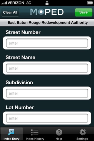
Property Condition Index which allows the following data to be captured and
stored by redevelopment authorities:
• UserID (required for activation)
• Lot ID (text entry)
• Street Number (text entry)
• Street Name (text entry)
• GPS location (captured automatically via internal mobile device)
• Subdivision (text entry)
• Lot Number (text entry)
• Block Number (text entry)
• Structure (y/n)
• Structure Occupied (y/n)
• Condition (good| fair | poor) – as a pull-down menu
• Property Maintained (y/n)
• Use (residential | medium-density residential | high-density residential
| commercial | office | industrial | public |semi-public | vacant |
undeveloped | agriculture | recreation) – as a pull-down menu
• Visible Contaminants (y/n – describe)
• Photo (captured via internal phone camera)